


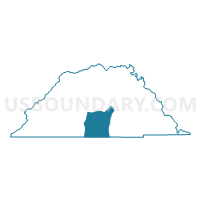
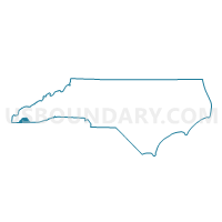
Voting District HIAW, Clay County, North Carolina
About
Outline

Summary
| Unique Area Identifier | 639690 |
| Name | Voting District HIAW |
| County | Clay County |
| State | North Carolina |
| Area (square miles) | 16.78 |
| Land Area (square miles) | 12.46 |
| Water Area (square miles) | 4.32 |
| % of Land Area | 74.26 |
| % of Water Area | 25.74 |
| Latitude of the Internal Point | 35.01907120 |
| Longtitude of the Internal Point | -83.75019110 |
Maps

Graphs
Select a template below for downloading or customizing gragh for Voting District HIAW, Clay County, North Carolina


Neighbors
Neighoring Voting District (by Name) Neighboring Voting District on the Map
- 281990 - HIAWASSEE Voting District, Towns County, GA
- Voting District HAY2, Clay County, NC
- Voting District SHCR, Clay County, NC
- Voting District TUSQ, Clay County, NC
Top 10 Neighboring County Subdivision (by Population) Neighboring County Subdivision on the Map
- Hayesville township, Clay County, NC (3,868)
- Hiawassee CCD, Towns County, GA (3,775)
- Macedonia CCD, Towns County, GA (2,669)
- Hiawassee township, Clay County, NC (1,578)
- Shooting Creek township, Clay County, NC (1,513)
- Tusquittee township, Clay County, NC (764)
Top 10 Neighboring Unified School District (by Population) Neighboring Unified School District on the Map
Top 10 Neighboring State Legislative District Lower Chamber (by Population) Neighboring State Legislative District Lower Chamber on the Map
Top 10 Neighboring State Legislative District Upper Chamber (by Population) Neighboring State Legislative District Upper Chamber on the Map
Top 10 Neighboring 111th Congressional District (by Population) Neighboring 111th Congressional District on the Map
Top 10 Neighboring Census Tract (by Population) Neighboring Census Tract on the Map
- Census Tract 9502, Clay County, NC (5,525)
- Census Tract 9501, Clay County, NC (5,062)
- Census Tract 9603, Towns County, GA (3,775)
- Census Tract 9602, Towns County, GA (2,669)